Tuesday, April 22, 2008

9. San Antonio - Fiesta

“Fiesta” in San Antonio is all about food, music and fun and it’s all over town. Market Square is the venue for Fiesta Fantasias. The market is a maze of small shops stuffed with everything from Mexican sombreros, pottery and wierd skeleton people to very fine (and expensive) art. Lots of good food was available at street booths and several stages were alive with local Tejano music and some dancing in the streets. We did a lot of walking, looking and sampling of gordidas and mini-tacos. Excellent!!!


The “Taste of New Orleans” is another popular Fiesta event. It's held outdoors in the Sunken Gardens of Brackenridge Park, a perfect setting. We took folding chairs, arrived early and got a good center spot to view the stage. Once again, food booths were everywhere, this time with lots of good Cajun delights. Ron dove into a bowl of shrimp, fish and sausage in a thick spicy sauce over “dirty rice”. Bonnie had a big crabcake with rice. We shared a shrimp-on-a-stick and couldn’t pass up the alligator-on-a-stick (hard to find in Seattle). The alligator tasted like we imagined it would, a bit tough and rubbery but with a nice flavor and plenty of Cajun spices.

Different bands took the stage and a local belly dancing group did a show as well. Ron especially liked the rough raspy jerky zydeco music that makes you want to dance right out of your chair. Since we know very little about that style, each song sounded pretty much like the one before. It would help if they'd sing the words in English instead of French. But it's a cultural thing and, since music is a universal language, nobody seemed to care. We’re looking forward to some slightly softer Cajun music in Louisiana.


The River Walk is the city's second most popular attraction (Alamo is first). This public walkway follows about three miles of the river as it winds through the center of downtown. It's lined with restaurants, pubs, shops and the best hotels. It's very nicely landscaped with plants and flowers, many very large trees and lots of birds. There are also lots of masonry walls, small bridges (that's Bonnie on the bridge), stairways and other attractive rock work. The River Walk is a comfortable relaxing "people place" away from traffic and noise. It's an excellent example of good planning and urban design.


We spent our final evening in San Antonio at the annual River Walk Parade. It’s a parade of boats/floats with lots of lights and music on the river. Thousands of tables and chairs were set up along the route in front of hotels and restaurants. We could sit in one for a fee of up to $25, but we opted to stake out a nice section of railing along Crockett Street overlooking the river. It was a great view, but standing up for hours was a little hard on us old folks. The restaurants went all out in their table decorations and mariachi bands were entertaining the patrons.


The parade and San Antonio in general were lots of fun. We’re leaving with a positive impression and hope to return some day.

Monday, April 21, 2008

8. San Antonio Missions & History

With a population of about 1.2 million, San Antonio is the second largest city in Texas (Houston is larger) and 7th largest in the U.S. But Texas has lots of room and low-density “urban sprawl” has flourished. The city spreads for miles and seems much smaller than more intense vertical cities such as Seattle, Chicago, etc. It’s easy to navigate the freeways and interconnecting loop routes. There are no mountains, lakes, coastlines or other major obstacles so streets and freeways radiate in all directions from downtown.

The Alamo was established in 1718 and its famous battle was a major event in Texas history. A small group of 189 Texans fought against Mexican General Santa Ana’s much larger army in 1836. The Alamo defenders, including Jim Bowie and Davie Crockett, were wiped out. Later, however, Sam Houston’s army defeated Santa Ana and Texas became an independent republic, and later a state.


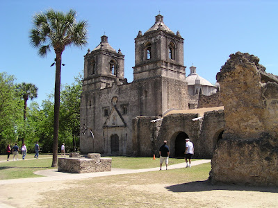
Four other missions have been preserved as part of the San Antonio Missions Nat’l. Historical Park. We visited two of them. The following two pictures are of Mission Concepcion. The third is the famous "Rose Window" at Mission San Jose (long story).


The King William District was settled in the 1800s by prominent German merchants and was the first historic district in Texas. Many of the beautiful old homes in this neighborhood have been preserved. One of those early pioneers was Ed Steves and we had an opportunity to tour his family homestead. Mr. Steves came from Germany, sold grain to Mexico markets illegally during the Civil War, invested wisely and eventually operated a successful lumber business that still thrives in San Antonio. He died in 1890 but his wife lived another 40 years and kept the house in excellent condition, complete with mostly original furnishings. The following photos will give you an example of the types of homes in this district. Too many for this page.

Saturday, April 19, 2008

7. This must be Texas

It was a long uneventful drive from Tucson, through a small section of New Mexico, past El Paso and on to San Antonio. The terrain consisted mostly of dry desert, sand, sage and lots of rocks. Long wide valleys were interrupted by low mountain chains . . . and the scene repeated itself over and over. It made us appreciate the great distances and vastness of this part of the country. Very few Starbucks.
We spent one night about 20 mi. west of El Paso and had a terrific front window view of the quiet desert, a few birds and a jackrabbit or two (see photo). The campground hostess knew nothing about the area, but we stumbled onto a very good Mexican dinner at a local truck stop restaurant.

We spent our first Texas night in Fort Stockton, a small windy dusty town. The campground hostess said we were lucky to get the last spot because Fort Stockton is a “boom town.” Apparently, the town was nearly dead until gas prices started to rise. Now, it’s once again cost effective to pump oil from lots of old oil wells in the area. So, all the rentals, motels and campgrounds are full of oil workers, the economy is healthy and there are three columns of oil-worker jobs in the local newspaper. Go figure. I guess we can feel good that we're contributing to the booming economy of places like Fort Stockton.

About a half hour short of San Antonio, we found the nice little historical village of Comfort . . . a perfect name for a quiet laid-back town full of old buildings, history and interesting shops. We walked around the downtown and stopped for refreshments at the oldest continually active soda fountain in the whole country. It has been operating for more than 100 years in a building that was built in 1854. It was here that Ron experienced the worst hot fudge sundae he had ever consumed. Can’t have everything. Bonnie's root beer float was no prize winner either.


We settled into Stone Creek RV Park, about 20 min. north of San Antonio, for a five night stay. “Festival” began yesterday. It’s a 10-day event that brings about 3.5 million visitors to the city each spring. There’s a lot to see and do and we can’t possibly do it all, but we hope to have some interesting photos in our next blog. So, stay tuned.

Monday, April 14, 2008

6. Arizona's Wild West

Cochise County, in the SE corner of Arizona, is home to the wild west town of Tombstone, the gunfight at the OK Corral, Boot Hill and lots of fascinating history and legends. It was also the home of Indian warrior Geronimo, the Chiricahua Apache tribe and its leader Cochise. He fought for 11 years to hang onto the tribal lands. He was never defeated in battle and is greatly admired around these parts.

Mining was big business in this area, especially copper mining. The hills are riddled with old mines, dried up ghost towns and old mining towns that found new reasons to survive. Mining is still done around Bisbee and Tombstone but they now rely heavily on their history to lure tourists, as well as newer arts, crafts and modern businesses.

Bisbee, the “Queen of the Copper Camps”, is very picturesque and interesting. It was built on the steep rocky hills of a narrow canyon and many of the homes rely on long steep stairways. By 1910, it was the largest, richest and rowdiest copper mining town in America and the biggest city between St. Louis and San Francisco.

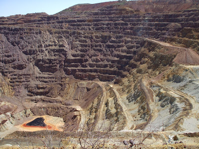
Local mines produced zinc, lead, silver, gold, manganese and nearly 8 billion pounds of copper. The Lavender Pit is a large open pit copper mine at the edge of Bisbee. It operated from 1951 until 1975. Lots of high quality turquoise also came from this mine.


Today, Bisbee is alive with small shops, art studios, antique stores and restaurants but small enough to walk and explore in a couple hours.

Tombstone was also a rowdy mining town, but is most famous for Doc Holiday, Wyatt Earp, Big Nose Kate and the 1881 gunfight at the O.K. Corral, which lasted only about 30 seconds.
The old buildings and boardwalks along several blocks of Allen Street of the original town are preserved. The Bird Cage Theater is the most historic and notorious of the structures. It remains largely as it was when it closed. We toured the building, peeked into the basement bordello rooms, saw the bar and card room, and studied the large assortment of memorabilia and artifacts that occupy the main floor of the theater. We were informed that this is considered the most haunted building in the U.S., although we didn’t experience any ghosts in the middle of the afternoon.


About 250 of Tombstone’s former residents are buried in the Boot Hill Graveyard, including the losers of the famous gunfight. A list of the occupants showed that very few died of “natural causes.” Most were shot or hanged, some died of unfortunate accidents, and others of illnesses of various kinds. The horse-drawn hearse that carried all but six to Boot Hill is in the museum at the Bird Cage Theater.


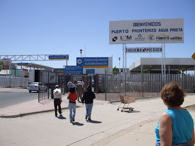
We decided to visit Mexico, but wanted to see a smaller town rather than a large border city. So, we drove the back roads through Texas Canyon, the one-horse “town” of Dragoon, the former mining town of Pearce and finally to the border town of Douglas. It cost just $1 to park in a municipal lot a block from the border crossing. From there, we walked into the small Mexican town of Agua Prieta. There was a lot of activity at the crossing. Apparently, a vehicle didn’t make it through the inspection and the border patrol and their dogs were swarming around, had a suspect on the ground, and a CHP helicopter was hovering overhead. We walked right on by with other tourists. Just another day at the border.
Agua Prieta wasn’t nearly as pretty as its name but the people were friendly, there were a few sidewalk food vendors and lots of interesting businesses. We walked several blocks into town and poked around in a few stores.

We purchased a few small souvenirs before returning to the U.S. We were armed with driver’s licenses, passports and other picture ID, but weren’t asked for anything. The border guard just looked at us, smiled and waved us through. I guess we’re too obviously American tourists. Maybe the Hawaiian shirt, shorts, funny Dakota farm hat and camera around the neck gave it away. It was just too easy!!!

5 - Tucson and Cactus

We discovered that southeastern Arizona is packed with more interesting things to see and do than we had time for. We set ourselves up at Cochise Terrace, a beautiful up-scale RV resort (paid half-price) 40 miles east of Tucson and convenient to places we wanted to visit. We had to stay an extra day to add time for essential tasks, a tour of Kartchner Caverns, a visit to Boot Hill and a very refreshing dip in the pool.

The Hoover administration had good foresight in 1933 in establishing Saguaro National Park well in advance of Tucson’s explosive growth. Suburban development has spread across the Sonoran Desert all the way to the park boundaries and probably would have eaten up the rest of the park as well as suburbanites strive for view homes amid cactus gardens. Fortunately, the park is well protected and offers visitors an opportunity to get a close-up look at a variety of cacti and other plants, especially the large saguaros (Ned of Taco Bell is one). We took the 8 mile Cactus Forest Drive and stopped along the way for short hikes and photos. Very nice!


Tucson is nearly as large as Seattle in population but, without many surrounding communities, it seems a lot smaller. It also appeared very clean, modern and much too quiet for a Saturday. We found our way around easily and parking was free everywhere we went.

We spent an afternoon in the Old Tucson district following a well-marked self-guided walking tour, looking at old buildings and historic sites, and learning about the area’s colorful history. St. Augustine Cathedral (1896) was a very impressive structure (photo). Old Town Artisans was an interesting cluster of artsy shops surrounding an outdoor eating patio under large shade trees, complete with a singing guitar player. It was across the street from the Presidio San Agustin del Tucson, which was established as a Spanish fort in 1775. Ron was especially excited about finding a small railroad museum near the beautifully restored Southern Pacific RR depot.

It’s easy to see why many snowbirds flock to this part of Arizona. The winter climate is just about perfect, the scenery is terrific and there are lots of things to do. We didn’t see everything, but hope to return in the future and spend a little more time here.


Wednesday, April 9, 2008

4. Left Turn to Arizona

I-5 to Bakersfield was long and flat, but the varied scenery of crops, cattle, and green rolling hills was better than expected and not at all boring. To conserve fuel, we cruised along with the truckers at a steady 55-60 mph. Even at that speed, the RV was pummeled with bugs and flying critters of all sizes, their colorful juices splattering the windshield like a game of paint ball. Ron’s first task at the end of a travel day is to scrub the windshield and front of the RV before the bug remains get baked on. That task took him half an hour when we finally settled into our space under the palms at the Bakersfield Palms RV Park (picture).

It was a long slow grind over 4,000 ft. Tehachapi Pass as we climbed out of the central valley and into the high desert. Again, the scenery was better than expected and some species of blooming cactus added color. We cruised through Barstow (no good reason to stop) and on toward the Colorado River. As we approached Needles, Bonnie was watching the gas gauge like a hawk as the needle pushed the empty mark. Fortunately, it was all downhill into the Colorado River Valley. We took the first gas station exit (big mistake) and found the price of regular gas to be $4.20/gal. We passed those stations and finally bought a few gallons at $4.10/gal. to get us up the road to Bullhead City. To our delight, gas was selling for only $3.22/gal. in Bullhead, just 35 miles north.

We spent the next three days visiting Bonnie’s sister Bev and her hubby Tom in Bullhead City. Their nice winter home overlooks the Colorado River valley and Eldorado Mountains to the west. We relaxed, did some laundry and clean-up, and spent an afternoon at a Laughlin casino losing a few bucks to the gambling machines but also enjoying a great $5.00 lunch buffet. Ron and Tom got to watch the final game of the NCAA college basketball tournament while Bonnie and Bev did a little shopping. Bonnie’s cousin Darrol came down from Kingman and they spent the afternoon recalling old times growing up in Bellingham many years ago. Ron and Darrol were on Navy ships in Vietnam about the same time, so they had some stories to share as well. Bev and Tom were very good hosts and fed us too well. Bullhead was a nice stop on our trip.


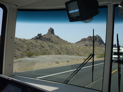
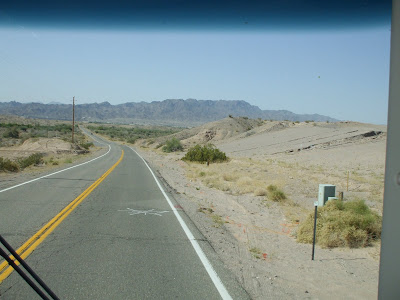
We departed Bullhead on Wednesday (April 9), drove down the river, passed by Lake Havasu and Parker and turned east at Quartzite. The highway was a bit narrow and slow but, as you can see, there wasn't much traffic. The jagged mountains near Needles and rocky terrain along the river were very scenic. There weren't any good viewpoints, so Bonnie clicked off a few pictures out the windows as we rolled along. It was sunny and warm but not warm enough to turn on the A/C.


Tonight (4/9), we’re camped on a patch of desert called Augie’s RV Park, just outside Gila Bend, Arizona. It’s more sand box than park, but it has its own unique character, as do most campgrounds. Our rooftop antenna couldn’t pick up any TV stations and there are more radio stations in Spanish than English, so this was a good time to relax, go for a walk and update the blog.

Gila Bend is a pit stop and we’ll leave first thing tomorrow for Tucson. We have a long list of things to see and do in that area. Adios amigos . . .

Monday, April 7, 2008

3 -- Wine Country

We arrived in the Alexander Valley in California’s wine country on March 31. We settled into a beautiful space at the Russian River campground, which is nestled in a narrow canyon full of oak and manzanita along the river a few miles north of Cloverdale.

Cloverdale is a nice little Mayberry kind of town, but with evidence of good planning and strict sign controls, with the exception of Pick's Drive-in, which was obviously "grandfathered in". After being dragged behind the RV for 800+ miles, the Honda was very dirty. Thanks to a do-it-yourself car wash, Ron managed to get it reasonably clean for only eight quarters. That left us with enough pocket change for a couple deluxe burgers at Pick’s, an authentic 50’s style burger joint. Delicious!

Budding vineyards and scattered wineries cover the rolling hills and valley floor of the Alexander Valley and the neighboring Sonoma and Napa Valleys. We took the Honda on a self-guided driving tour of the valley for a close-up view (and taste) of the grape-based economy. We started at the River Rock Casino, a huge complex sitting high on a hillside and visible for miles. Three five-story parking structures and a fleet of tour buses from the Bay Area filled the casino with people, cigarette smoke and noise. We joined the Players Club (free) and cashed in some visitor vouchers that got us an excellent two-for-one lunch buffet and $30 worth of free gambling, which we managed to lose in about five minutes before escaping.


The grassy hills are bright green this time of year, the grapes are just getting started and the country drive was very pleasant. We bought some oranges and avocados at a little roadside stand before entering the town of Healdsburg (pop. 11,700). It’s also a very attractive community with a people-friendly town square surrounded by attractive shops, restaurants, antique stores, lots of wine tasting rooms and people talking on cell phones.


We could have stayed at Russian River another week or two, but it was time to move on. Figuring out how to get from Highway 101 to our next campground near Manteca proved to be a challenge. To avoid the dreaded Bay Area traffic and congestion, we plotted a 15-step course that followed mostly winding narrow country roads around the north side of San Pablo Bay, and eventually to I-80, I-680, I-580, I-5 and eventually to Turtle Beach RV Park. It was a strenuous exercise in highway navigation but Bonnie juggled the maps gracefully and gave good accurate directions while Ron dodged the truckers. We didn't miss a turn.

Turtle Beach is on the San Joaquin River, a few miles south of Manteca. We arrived early enough to go into town, do a little shopping at Wal-Mart and relax with an excellent Mexican dinner. [Note: Thanks to a misspelling long ago, Manteca means “lard” in Spanish.] This is a quick rest stop. Tomorrow morning we’ll head for Buck Owens territory (Bakersfield) and on to Arizona.